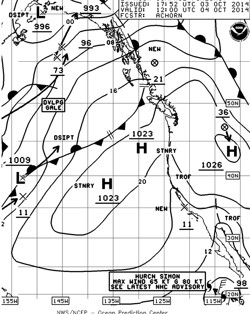
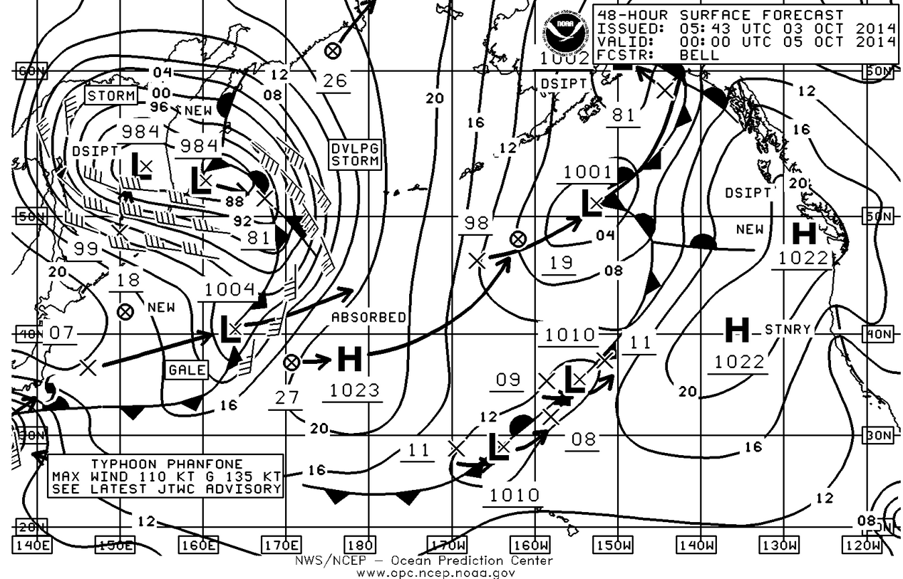
Another pretty great week in the Pacific Northwest however as you can see from the surface charts, the change is coming. As far as this weekend and the Foulweather Bluff Race goes there just isn’t going to be a lot of wind. Let’s hope the Race Committee follows the old rule of checking the gradient spread over the Pacific Northwest before trying to send us on the long course.
So how do you check the gradient spread over the Northwest and how does that translate into wind speed and direction? Tomorrow morning you can do a quick check of the gradient by looking at current Western Washington Surface Conditions at:
http://www.atmos.washington.edu/cgi-bin/latest.cgi?sfcplots-wwa
For conditions in the north Sound I would look at the pressure at Bellingham labeled KBLI on the chart and you would see three green numbers 245. This is NWS short hand for the barometric pressure in millibars and means 1024.5 mb. Then check the pressure in Olympia KOLM and you’ll see 236 which is 1023.6 mb. Subtract the difference between Bellingham and Olympia and you get .9 mb. Multiply times 10 and you get 9 which should be the approximate wind speed and if you check Paine Field it shows 5 knots and if you check West Point it shows 8 knots, so pretty close. Then just remember that wind flows from areas of higher pressure to areas of lower pressure so the direction should be northerly. A quick check of the pressures along the coast show an almost 2 mb gradient difference which would add an easterly component to the wind and sure enough both Paine Field and West Point show wind from the NNE.


What do you do if you’re on the boat and don’t have an internet connection? Just use your VHF radio and as soon as you step onto the boat in the morning start logging the pressure reports from NOAA Weather radio. About every 15 minutes they will give you the pressure in mb’s from Forks, Bellingham, Sand Point, Portlandia, Astoria, North Bend (OR), and Wenatchee. They upgrade this information about every three hours so it gives you an idea of how the gradient is changing over the NW. For conditions in the north Sound I’ll take the pressure between Bellingham and Sand Point and if the pressure is higher in B’ham then multiply times 5. It’s not perfect but it’s a quick way to develop your own forecast. Needless to say if there’s only a couple of 10ths in pressure difference over the whole NW, the breeze is going to be light.
I look at three models for forecasting, PredictWind C, PredictWind G, and UW MM5. The PW models are based on dividing the atmosphere into 8km cubes while the MM5 is based on a 4km cube. PW offers a 1km cube however it isn’t available until the day of the race. UWMM5 offers a 1-1/3km cube but since it takes a whopping amount of computer calculations to do this, it is very slow coming out and usually doesn’t finish until late in the afternoon of the day before.
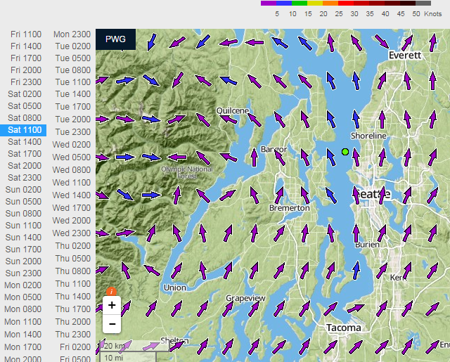
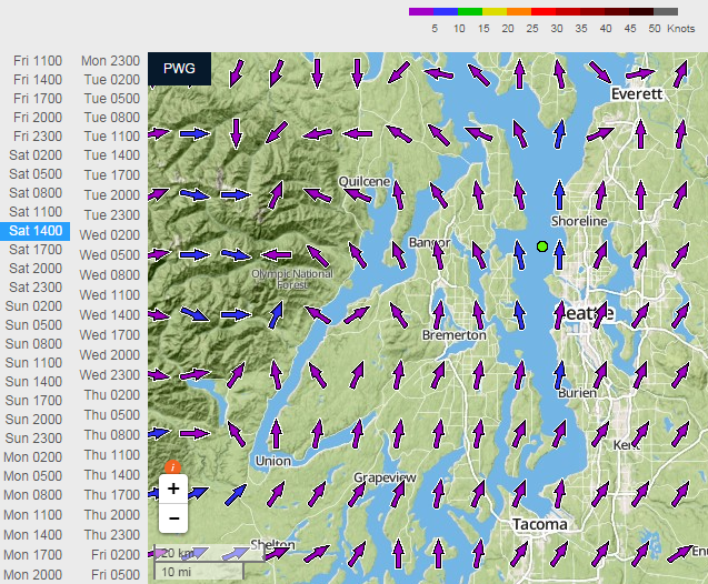
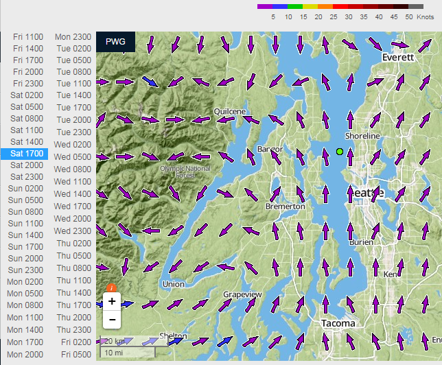
As of Friday afternoon we should all hope the PWC model is going to prevail as it shows 5-10knots from a generally southerly direction over the entire course for the entire day. The PWG Model shows 5-10 from the south at 1100 hrs becoming 0-5 from the south at 1400 hrs on the west side of the Sound while holding 5-10 from the south on the Edmonds shore. By 1700 hrs the entire north Sound shows 0-5 from the south.
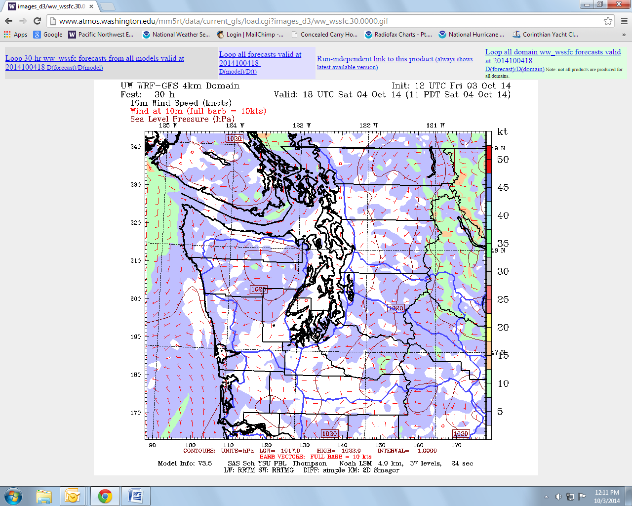
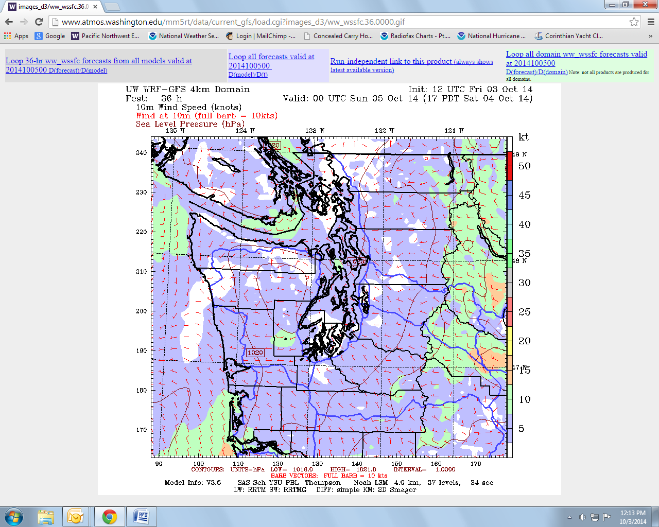
The MM5 chart is quite different showing 0 gusting to ½ for the start from nowhere in particular. By 1400 hrs MM5 show a weak 5-knots from the NNW with plenty of holes. By 1700 hrs it shows a more consistent yet light 5 knots of northerly over the entire Sound. We’ll see.
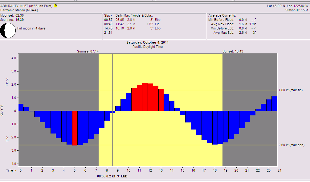
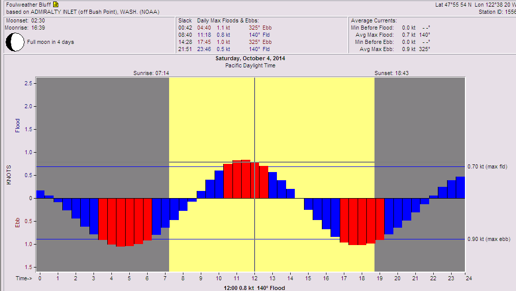
The other problem is the tide which we know waits for no one. It will be flooding from about 0900 until about 1500hrs. In light air this will make the Scatchet Head and Foulweather Bluff marks fairly challenging. In both cases since you have marks near bluffs and you have a day which will start out cloudy and gradually clear. As the clearing occurs the bluffs will heat up and what wind there is will lift off the water near the marks. Since the marks are in relatively shallow water you have the compounding problems of increasing tidal current velocity the closer you get to the marks combined with decreasing breeze. Not a great situation for sailboats. Max flood in Admiralty Inlet will be just over 2 knots just before noon. I also gave you the current for Foulweather Bluff which happens to be very close to the current that will be running at Scatchet Head. Max flood at Scatchet Head should be sometime between 1130 and noon and will be just under a knot running at 090°M to 120°M.
The good news in all of this besides the fact that CYC Edmonds is a great host is that the local knowledge guru for that area is racing and he will be among the first boats to start so just watch where he goes. That person is Gay Morris who will be racing the Shark 24 Fayaway sail number 1764. He won the Double Damned event in the Gorge this summer with the Shark and he consistently does very well sailing out of Edmonds.
Remember that the courses are reversed this year so the first mark for every course is Scatchet Head. So remember to keep track of the bearing to the mark relative to the land so you can see how much you’re being set as you approach the mark. Get the boat as light as possible, sail with minimum crew, and concentrate the weight in the middle of the boat, nothing in the ends. Light air trim is a never-ending job as is light air helming so get your best trimmers and drivers ready for a long day. Rig the barber haulers and light air sheets and don’t let the crew accumulate in the cockpit. Body pack around the shrouds and the mast to lift the stern and reduce wetted surface area. DON’T PINCH. Focus on boat speed and have the crew on the rail call puffs, incoming waves, and those speed robbing patches of kelp and eel grass. You also might want to take along a light spinning outfit and drag a coho streamer behind the boat. They are really out there this year and if the committee sends us from Scatchet Head to the Pilot Point mark that is prime territory. Hopefully we’ll just go to Scatchet Head and back where there will be plenty of coho as well.
Good luck, have a fun time out there and I hope to have a follow-up report for you on Sunday or Monday.
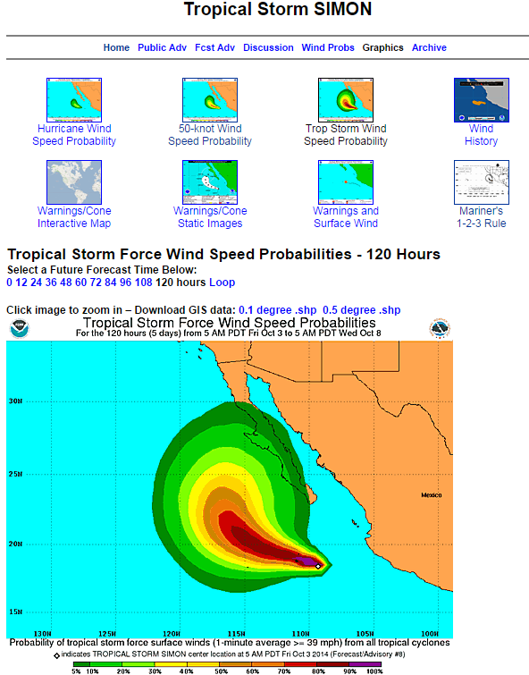
Now for the rest of what’s interesting, how about hurricane Simon off of guess where, Baja California. Again, not moving very fast but could hit Baja near Cedros Island and cross over into the Sea of Cortez bringing even more rain to places that really don’t need it. Plus we still have all of October and all of November to go until hurricane season calls it quits for the year and we only have seven letters left to go in the named storm file so it could get interesting.
Enjoy your weekend on the water it is going to be beautiful out there.
